
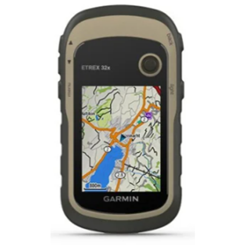

GARMIN ETREX 32X.
- GPS and GLONASS Support: Provides accurate location tracking, even in challenging environments like dense tree cover or hilly areas, which is useful for mapping farm boundaries and navigating large fields.
- 3-Axis Compass and Barometric Altimeter: Helps with precise navigation and elevation tracking, useful for terrain mapping on farms with varying topography.
- Preloaded TopoActive Maps: Includes maps with routable roads and trails, helping to navigate through farmlands, especially in remote or less-developed areas.
- 16 Hours of Battery Life: Long battery life ensures continuous operation for a full day of work on the farm without needing frequent recharges.
- MicroSD Slot for Additional Maps: Allows you to load custom maps, such as agricultural land maps, soil data, or irrigation layouts, to tailor the device for farm use.
- 2.2″ Color Display: The sunlight-readable display makes it easy to view maps and data while working outdoors.
- Custom Waypoints and Routes: Helps mark specific locations on the farm, such as irrigation systems, fences, barns, or fields for planting or harvesting.
- Rugged Design: Water-resistant (IPX7), making it durable enough to withstand outdoor farm conditions like rain, mud, or dust.
- Area Calculation: Can calculate the size of fields and paddocks, useful for land measurement, crop planning, or livestock management.
- Trackback Feature: Allows you to easily navigate back to your starting point, which is useful when working in large or unfamiliar farm areas.
- These features make the eTrex 32x a valuable tool for managing large farm operations, mapping fields, and navigating across diverse terrain.

Reviews
There are no reviews yet.